1
Day 01: Arrive at Islamabad International Airport, Islamabad
On this Day
GPS Data
Altitude: 540 m
The participants will be picked by the guide from the Islamabad Internation Airport. All the participants will rest today.
Pickup information
Our guide will wait on the International Arrivals with the name placard and company logo. The guide will be available at the airport at the given time by the guest. Upon receiving, you will be transferred to the hotel.
After lunch and some rest at the hotel (ideally if you are arriving in the morning between 9 am to 12 pm), our guide/representative will pick up all our guests around 6 pm for briefing and remaining payments at our office followed by a dinner. If you are coming late, we will manage the remaining payments and briefings in Skardu.
2
Day 02: Fly to Skardu, Karakoram
On this Day
GPS Data
Altitude: 2,498 m
Participants on this morning will take the spectacular flight from Islamabad airport to Skardu airport. You will be able to see Nanga Parbat if clouds allow. After arrival in Skardu, the day is free.
3
Day 03: Spend free day in Skardu
On this Day
GPS Data
Altitude: 2,498 m
After breakfast, the participants will walk to Kharpocho fort in Skardu, which is located up on a mountain. The Kharpocho fort gives a splendid view of the Indus and Skardu town. The participants will also have an option to take a tour to Sadpara Lake followed by free shopping time in Skardu Bazaar.
During sightseeing, our staff will take care of further government documentation required in Skardu. This can sometimes take two days. We have contingency days towards the end of the trek in case of any delays.
4
Day 04: Drive to Askole village
On this Day
GPS Data
Altitude: 3,015 m
The participants will begin the jeep safari towards Daso, the passage will go through the Shigar valley. The journey will be followed on the sides of Braldu river which extends to Askole. Askole will be the last village on our route; the participants will start walking after leaving jeeps behind. However, at times the participants may begin their walk before arrival in Askole but it depends on the road conditions. Overall it will take you between six hours to eight hours in covering the distance.
5
Day 05: Trek from Askole to Jhola via the snout of Biafo Glacier
On this Day
GPS Data
Altitude: 3,103 m
Distance: 20 km
Time: 5-8 hours
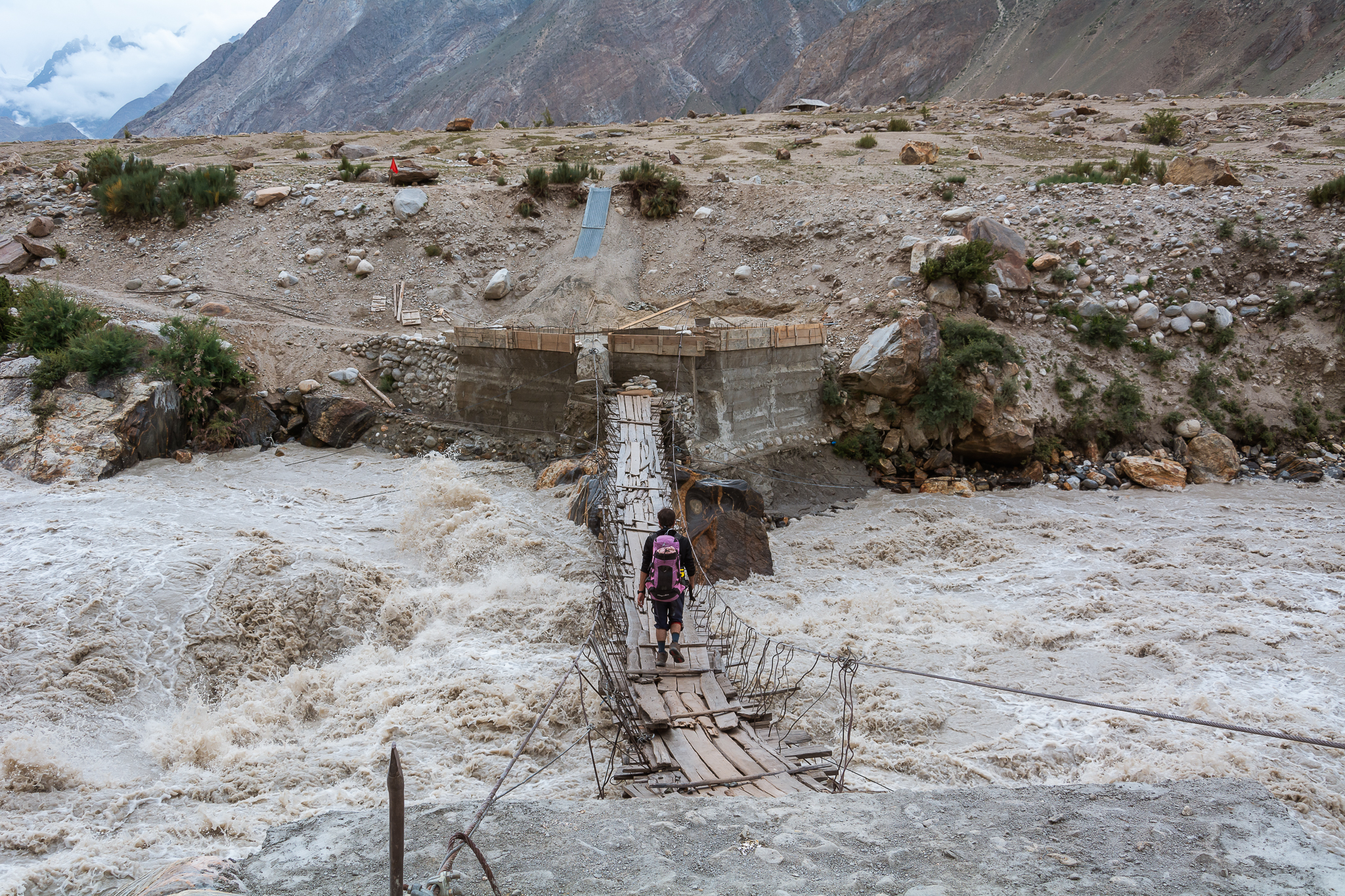
After completion of the necessary supplies list and equipment, the porters will load up for the trek ahead to Jhola. The valley is a gateway to Biafo glacier that flows over fifty km from Hispar La to Braldu. The participants will experience the moraine walking as the snout of the glacier is crossed and they will descend to lunch spot beside the Korofon river.
The route will take us the confluence of rivers of Braldu and Domordo. The former trail is not taken for the trek and instead, a newer trail will lead us to go upstream where the participants will cross the river by bridge. On the other side of the bridge, the participants will descend to the edge of the Braldu river and will follow the river bank to reach the camp at Jhola.
6
Day 06: Trek from Jhola to Paiju following the Braldu river
On this Day
GPS Data
Altitude: 3,418 m
Distance: 19.8 km
Time: 6-7 hours
On this day of our K2 base camp trek the participants will follow the Braldu gorge, along the bank of Braldu river. The participants will be able to view astonishing rocks of Trango Tower and Cathedral Peak. The participants should prevent themselves from possible sun burns and during this day as the walking conditions can be very dry and hot.
Several streams from glacier flow down into the valley and on the way the participants will have to use river crossing shoes depending on the water levels. The participants will be able to spot the snout of Baltoro Glacier on a clear day. On this day the participants will end their day by climbing away from the river to camp at Paiju, the last camp where you will see trees until for a while.
7
Day 07: Acclimatize and rest in Paiju
On this Day
GPS Data
Altitude: 3,418 m
The participants will spend the day at Paiju Camp for acclimatization and rest. However the porters will take their time to bake themselves bread for next week on the glacier. Acclimatization walk can also be taken towards Paiju Peak base camp on this day.
8
Day 08: Trek from Paiju to Khoburtse
GPS Data
Altitude: 3,788 m
Distance: 14.7 km
Time: 5-7 hours
On this day the walking will get tough however the scenery will become amazing with each step taken onto the snout of Baltoro Glacier. The trail has continuous up and down climbs on the glacial moraine, although the trail is quite safe it is highly recommended to be careful at all times. The participants will experience the stunning views as they move ahead; the views of Trango Tower and Uli Biaho. The participants are required to go across the glacier to Liligo. From this point, the participants will follow a rocky trail which is along the edge of the Baltoro or sometimes to Khoburtse, the side of the glacier where camp will be made.
9
Day 09: Cross small glaciers and walk to Urdukus
On this Day
GPS Data
Altitude: 3,905 m
Distance: 6.4 km
Time: 4-6 hours
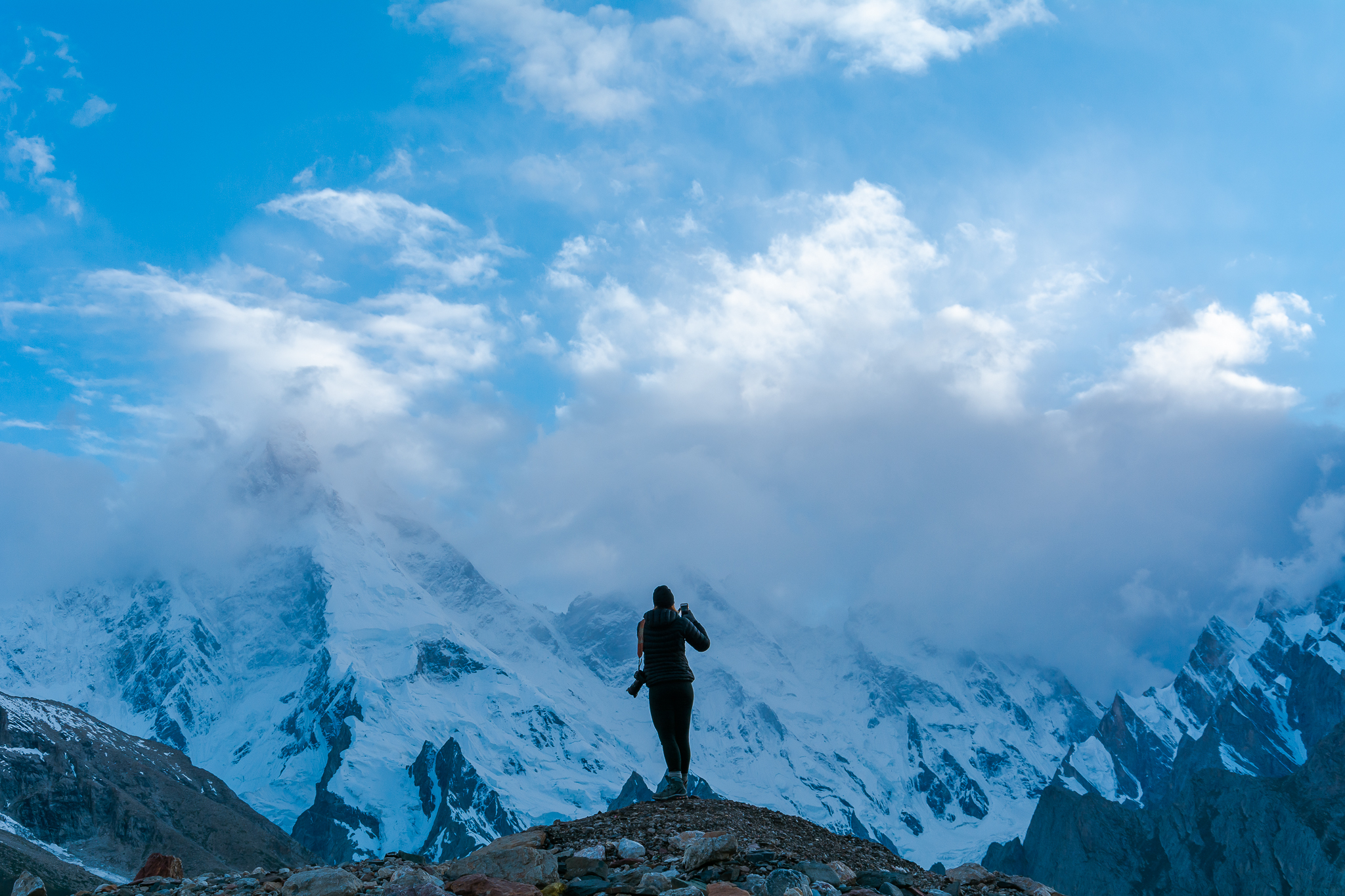
Trango Towers can be eventually seen after coming across two small glaciers. For the following night, the participants will make their stop at Urdukas near the army camp. The camp is 100m above the glacier.
10
Day 10: Trek to Goro II, the junction of the Baltoro glaciers and Young husband
On this Day
GPS Data
Altitude: 4,285 m
Distance: 11.9 km
Time: 6-8 hours
On this day of our K2 base camp trek, the participants will be walking in the middle of the glacier. The medial moraine will be followed, to the south, we will get the views of Masherbrum (7821m). The participants will be climbing up and down on the rocky moraine and as the participants move ahead they will walk pass massive ice seracs.
This will be the first-night stay camp on Baltoro Glacier at Goro II, it is the confluence of Baltoro Glacier and Younghusband. The temperature may drop dramatically. Masherbrum and Muztagh Tower will be uncovered for the sight.
11
Day 11: Trek to Concordia through a rocky moraine
On this Day
GPS Data
Altitude: 4,512 m
Distance: 11.7 km
Time: 5-7 hours
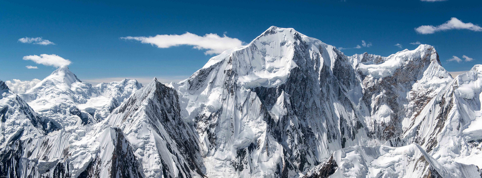
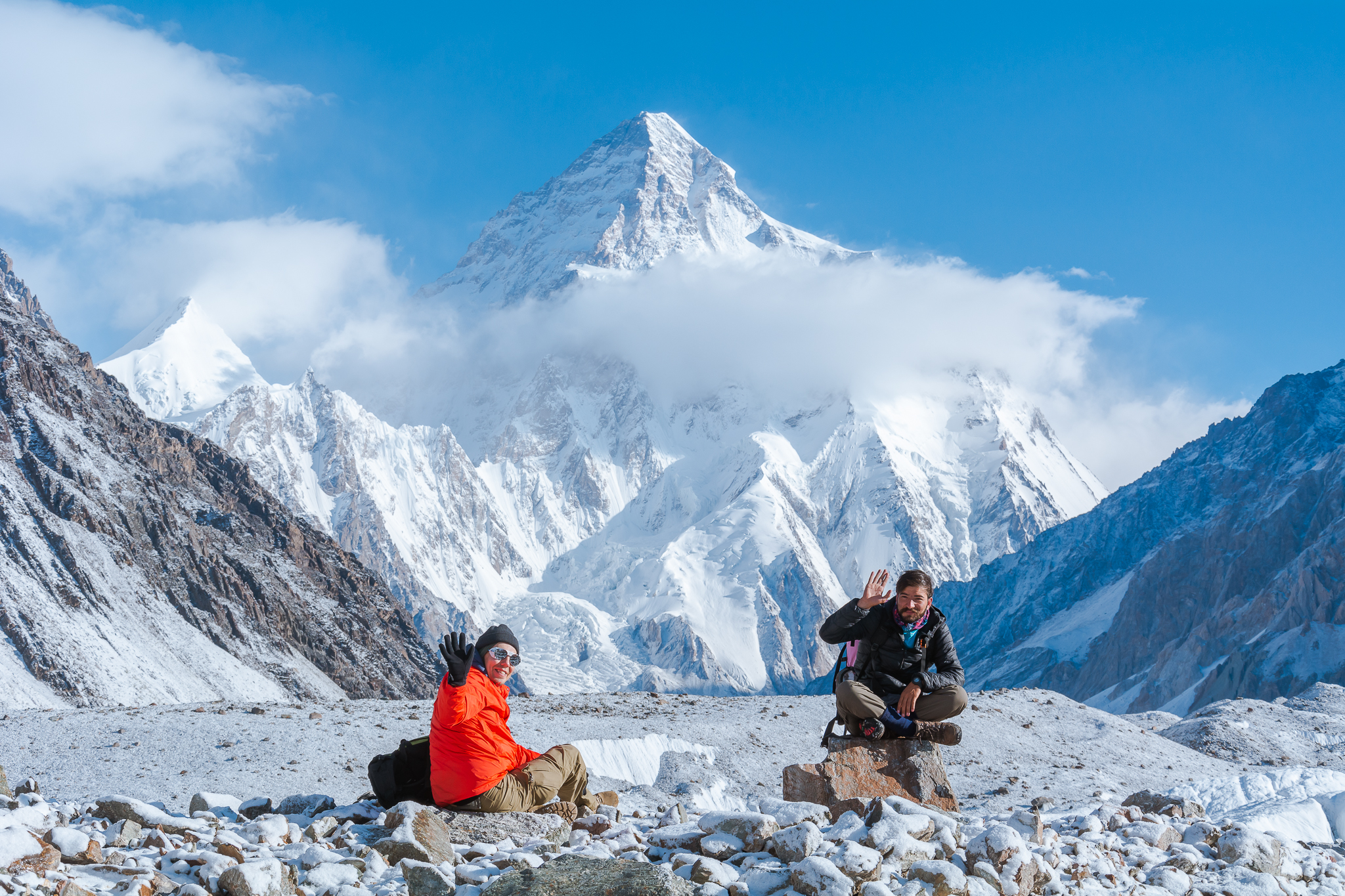
On this day of the K2 base camp trek, the participants will reach Concordia after continuously walking up the moraine, on the way more and more high snowcapped peaks will appear, the culmination for the sighting of K2 will be experienced on this day. Other peaks that can be seen include Broad Peak, Mitre Peak, Gasherbrum, Sia Kangri and many more.
12
Day 12: Trek to Broad Peak BC, Gilkey Memorial and K2 Base Camp (optional)
On this Day
GPS Data
Return time K2 BC (5,155m) + Gilkey (5,230m)+ Broad Peak (4,844m): 10-12 hours
Return time Broad BC (4,844m): 6-7 hours
Today there is the opportunity to walk up the Godwin-Austen glacier to the Art Gilkey Memorial (an American geologist and mountaineer) just before K2 Base camp. This is a very long but spectacular day. We will leave early morning, crossing the glaciers onto the faint trail heading towards K2 (there is a faint rocky trail all the way). As we follow the glacier towards K2 the mountain seems to grow bigger and bigger. Broad Peak rears up to our right and after about 3 hours we pass Broad Peak base camp (there is the option to turn back here). We usually have our lunch break here and then those who are continuing to carry on with K2 towering above us as we get closer and closer.
Just before base camp, amongst the boulder and ice strewn landscape is the Art Gilkey Memorial. A short scramble brings us to the place where those whose life K2 claimed are remembered. Plaques and engraved tin plates are attached to a small rocky outcrop at the foot of this great mountain. There are great views directly above us of K2 and we may see some climbing expeditions. After lunch, we retrace our steps back to Concordia.
13
Day 13: Trek to Goro I/Biango
On this Day
GPS Data
Altitude: 4,010 m
Distance: 15.9 km
Time: 6-7 hours
On this day of the K2 base camp trek, the participants will have to leave this camp and move back towards Goro I. The trek on this day will be quite easy and you will be descending down.
14
Day 14: Trek to Khoburtse with views of Trango Towers
On this Day
GPS Data
Altitude: 3,788 m
Distance: 13.8 km
Time: 5-7 hours
On this day the participants will make their way to the campsite of Urdukas, they will follow the same trail down via the glacier to Goro I. They will experience great views of Trango Towers before their arrival at Khurburtse. Even though the participants will be going on the same trail, however, the views on the way back will be completely different.
15
Day 15: Trek back to camp Paiju
On this Day
GPS Data
Altitude: 3,418 m
Distance: 14.7 km
Time: 5-7 hours
The participants on this day of the K2 base camp trek will be walking down on the side of the glacier via Liligo, this will be the last area where they will be shifting their trail from the moraine on the relatively stable ground. The participants will have the opportunity to find themselves in the trees after a break and enjoy their stay at Paiju campsite.
16
Day 16: Trek to Jhola campsite
On this Day
GPS Data
Altitude: 3,418 m
Distance: 19.8 km
Time: 5-7 hours
The walking on this day will be quite easier as the participants will be following the same trail to the Bradlu gorge. However, there may be some river crossings this day. The campsite will be made at Jhola.
17
Day 17: Trek to Askole and drive to Skardu town
On this Day
GPS Data
Altitude: 2,498 m
Distance: 20 km trek + 127 km drive
Time: 5-7 hours trek + 6 hours drive
On this day the participants will be back to Askole village after walking up the side of the river to the bridge. The participants will give some relaxation to their feet as they will be transferred in jeeps after lunch to Skardu.
18
Day 18: Contingency days for trek delays
On this Day
GPS Data
Altitude: 538 m
This day is allocated for any potential delays during trekking. We do not want our guests to miss their domestic flights due to delays. These delays can be caused by multiple factors including (but not limited to) roadblocks. This time can be utilized for sightseeing in Skardu.
19
Day 19: Fly to Islamabad
On this Day
GPS Data
Altitude: 538 m
On this day the participants will take a flight from the airport in Skardu to Islamabad airport. You will have a good time relaxing at the hotel in Islamabad.
The domestic flights sometimes get canceled due to weather conditions. In case of flight cancellation, you will drive to Chilas for overnight. It takes eight to ten hours by vehicle.
20
Day 20: Contingency day for flight cancellation
This day is allocated for any potential delays in case the domestic flight does not operate the previous day. Our guests will depart early morning from Chilas to Islamabad which can take up to ten hours. However it will be a free day in case the participants make it to Islamabad on the domestic flight. This time can be utilized for sightseeing in Islamabad.
21
Day 21: Fly to home country
On this Day
Meals included: Breakfast
Our staff will transfer all our guests to the airport on their respective departure timings. The checkout time of all our partner hotels is 12pm.


Dennis Talley
In quis vero omnes eum. Mazim accumsan interpretaris ad his. No affert adipiscing mel. No vix libris mollisquis vero omnes eum. Mazim accumsan interpretaris ad his.
Ryan L. Rasmussen
Lorem ipsum dolor sit amet, meis recteque his no, quem mentitum adipiscing pri an, dolorem copiomeis recteque his no, quem mentitum adipiscing pri an.